Can You Answer This Borders of Texas Quiz?
Ashley | 14 - 10 - 2020
Updated: October 14, 2020 7:05 am IST
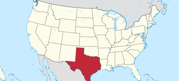
Texas is located in the south-central region of the United States. It is considered to be the second-largest state by area and population. Texas shares borders with several states including states of Louisiana, Arkansas, Oklahoma, New Mexico, etc. If you are a person who is so much interested in learning about the geography of Texas. Play the border of Texas quiz and border of Texas trivia to discover more interesting facts.
1. Which State Borders Texas to the East?
Texas shares its border with Louisiana to the east. It is a Southeastern US state on the Gulf of Mexico. The state is named after King Louis XIV of France.
2. Which State Borders Texas to the North?
Texas shares its border with Oklahoma to the north. Oklahoma is a state in the south-central region of the United States. The nickname of Oklahoma is “The Sooner State”.
3. Which State Borders Texas to the Northeast?
Texas shares its border with Arkansas to the Northeast. It is a Southern US state that is known for its beautiful nature including the wild terrains, hot springs, and rivers.
4. Which State Borders Texas to the West?
Texas shares its border with New Mexico to the west. It is a state located in the southwest region of the United States. New Mexico is known as a wine country. Santa Fe is the nation’s highest state capital.
5. Which of the Mexican States Does Texas Share Its Border With?
Chihuahua is the Mexican state that Texas shares its border with. It is considered the richest state in Mexico because of its huge contribution to livestock production and mining.
6. With Which State Texas Has a Coastline to the Southeast?
Texas has a coastline with the Gulf of Mexico to the Southeast. It is considered the largest gulf in the world. It is the tenth-largest water body on the planet.
7. How Far Is Dallas to the Mexican Border?
The approximate distance between the Dallas city and the Mexican border is 934 miles. Dallas is a modern metropolis that is located in north Texas.
8. Along Which River the State El Paso Is Located?
El Paso is a city in Texas that is located in the Chihuahuan Desert, along the Rio Grande River. This river is one of the principal rivers in the Southwest United States and Northern Mexico.
9. Houston Is Located along the Upper Texas Gulf Coast
Houston, a city in Texas is located along the upper Texas Gulf Coast. You can also find cities such as Corpus Christi and Galveston in the Gulf Coast region.
10. Austin Is Located in a Place Where the Rio Grande River Crosses the Balcones Escarpment
Austin, a city in Texas is located in a place where the Rio Grande river crosses the Balcones Escarpment. It creates a limestone formation separating the Texas Hill Country from the Blackland Prairies.
11. San Antonio Is Located at the Headwaters of the Rio Grande River
San Antonio of Bexar county, US is situated at the headquarters of the San Antonio River. It is the second-most populous city in Texas.
12. Plano Includes a Small Portion That Extends into Denton County
Plano is a city in Texas with a total area of 71.6 square miles. Most part of Plano lies within Collin County but a small portion of it extends into Denton County.
13. Laredo Is on the West End of the Rio Grande Plains
Laredo is a city in Texas, United States. It is located on the west end of the Rio Grande plains, south of the Edwards Plateau, west of the coastal plains, and east of the Mexican Mountains.
14. Laredo Is Considered One of the Principal Border Crossings from Mexico into Texas
Laredo is a city in Texas with a total area of 102.6 square miles in which around 1.5 square miles are surrounded by water. It is considered one of the principal border crossings from Mexico into Texas.
15. The Woodland Has Its Portions Extending into Tarrant County
The Woodland is in the U.S state of Texas with an area of 43.9 square miles. It is primarily located in Montgomery County, extending its portions into Harris County.